Kahana Bay Beach Erosion
Posted by Start An Offer on Thursday, April 14th, 2022 at 12:04pm.
KAHANA BAY EROSION MITIGATION
PROJECT OVERVIEW
For decades, the shoreline of Kahana, Maui has experienced severe coastal erosion from sea level rise (SLR), storm events, and shoreline development. This has resulted in risk to public safety, threats to environmental quality, reduced coastal access, and damage to property and infrastructure. Almost all the properties in the project area have some form of shoreline erosion control, from seawalls to vegetated berms. The community is seeking ways to manage the important resources of Kahana Bay for generations to come. The Proposed Action presents a sustainable, resilient, community-based solution to mitigate regional shoreline erosion that could serve as a model for nature-based approaches to the severe impacts of climate change and sea level rise for Maui County. WHERE
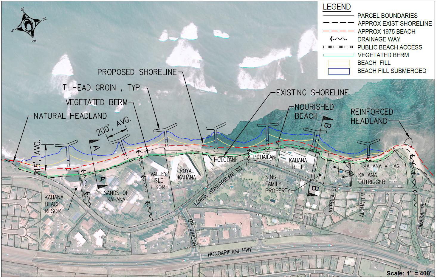
The project area stretches approx. 3,700 feet along the northwest Maui coastline between Kahana Stream and Pōhaku Park. A map of the project area is shown to the right. Offshore sand borrow locations are offshore of the Pōhaku Beach Park.
WHO
The Kahana Bay Steering Committee (KBSC) represents nine condominiums and one kuleana parcel. The KBSC contracted Oceanit, a Hawai‘i-based engineering firm, as the lead engineering and planning firm for the project. Oceanit has partnered with local specialists to conduct specialized studies, collaborate with the community, and prepare deliverables necessary for the project to proceed to construction. WHY
The purpose of the Proposed Acton is to design and implement a regional, sustainable, and resilient approach to mitigate the erosion hazard along the Kahana shoreline. The Proposed Action was developed with extensive input from many key stakeholders in the community, including public agencies, local non-profits, cultural leaders, and concerned citizens. The project is envisioned as a holistic approach to restore a widened beach, mitigate future erosion, and stabilize onshore and benthic conditions over the long-term.
WHAT
The Proposed Action, beach nourishment with stabilizing structures, contains three elements. BEACH NOURISHMENT will include dredging, transporting, and placing approximately 50,000 - 100,000 cubic yards (cy) of sand from identified offshore borrow areas. These activities are designed to restore the beach to a 1975 target beach width. A BERM ENHANCEMENT using dredged sand and planted with native coastal flora along the backshore of the beach profile will help provide wave run-up protection and serve as a sand reservoir for the beach system. To help keep the restored sand in place, SEVEN BEACH STABILIZING COMPOSITE T-GROINS will extend
perpendicularly from the shoreline to about 215 ft offshore on average, each with approximately 200 ft-wide on average breakwater sections. In addition, the headland at the north end of the project area will be reinforced with imported boulder stones.
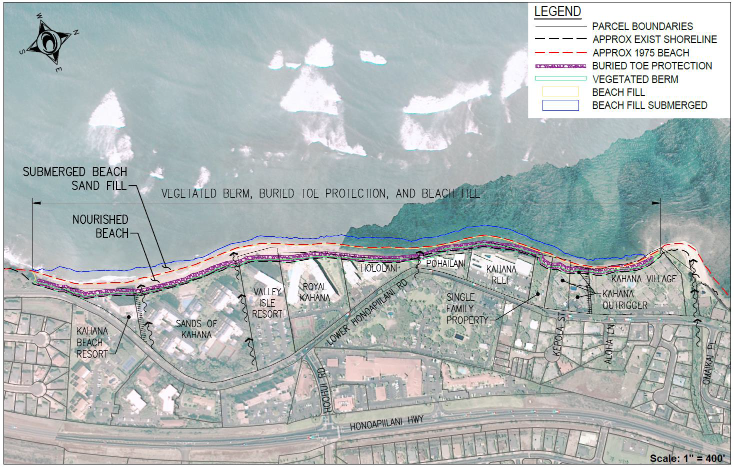
A Secondary Alternative, beach nourishment without stabilizing structures, was evaluated throughout the DEIS as it meets the project objectives but would be overall less sustainable than the Proposed Action. The Secondary Alternative includes beach nourishment, a vegetated berm, and buried toe protection. Under the Secondary Alternative, beach renourishment is estimated to be needed about every nine years. In contrast, with T-groins, beach renourishment would be needed about 30 years after construction. HOW
The KBSC and Oceanit, in consultation with public agencies and the community, evaluated project alternatives and developed the Proposed Action and Secondary Alternative. The detailed evaluation studied coastal processes; terrestrial and marine habitats; the cultural, social, and economic environment; and public services and infrastructure. Extensive community outreach efforts were also highly influential in determining the scope of DEIS studies and content. WHEN
The Environmental Preparation Notice (EISPN) was published in the March 8, 2019 Environmental Notice and re-published in the July 8, 2019 Environmental Notice to add a potential Maui County funding option. The Draft Environmental Impact Statement was published in the April 23, 2021 Environmental Notice, and the 45-day public comment period ends on June 7, 2021.
COST
Construction costs for the project are estimated to be $19M - $30M. Beach renourishment costs over the 50-year life-cycle are estimated to be $7M - $10M. The total project cost for the Proposed Action is estimated to be between $26M - $40M. Three options are being explored to fund of the Proposed Action: (1) private funding, (2) formation of a Maui County Community Facilities District (CFD), and (3) Federal Emergency Management Agency (FEMA) Building Resilient Infrastructure and Communities (BRIC). The project could be funded with a combination of sources in a public-private partnership. PUBLIC INPUT
Public input, questions, or comments are welcomed and encouraged until June 7, 2021. Questions may be directed to (808) 531-3017, and comments should be submitted electronically to: kahana@oceanit.com.
The full text of the DEIS is available at: http://oeqc2.doh.hawaii.gov/EA_EIS_Library/2021-04-23-MA-DEIS-Kahana-Bay-Erosion-Mitigation.pdf.KAHANA BAY EROSION MITIGATION
PROPOSED ACTION
BEACH NOURISHMENT WITH STABILIZING STRUCTURESBEACH NOURISHMENT
Sand will be dredged from three offshore borrow sites to restore the beach to its approximate 1975 width.
• Avg. beach width will be ~65 ft
• Width will be 50-80 ft depending on location
• Will create continuous lateral shoreline access
SECTION 2.2.1 (PG 17)
VEGETATED BERM
Dredged sand and native coastal flora will create a berm along the makai side of the adjacent properties.
• Provides wave run-up protection
• Serves as sand reservoir for a sustainable beach system
• May help slow frequency of future beach renourishment and reduce the need for dredging to replenish beach in the future
SECTION 2.2.2 (PG 18)
STABILIZING STRUCTURES
Seven T-groins and one reinforced headland will extend approx. 215 ft on average offshore, creating six coves.
• Designed to keep sand in place over the long term
• May provide new marine habitat and act as artificial reef by providing hard substrate and niche space for fish and other species
SECTION 2.2.3.3 (PG 22)
The Secondary Alternative evaluated in the DEIS—beach nourishment without stabilizing structures—will also include beach nourishment and a vegetated berm but will have buried toe protection rather than T-groins.
Without stabilizing structures, the Secondary Alternative would require renourishment about every nine years, which may eventually cause issues with sand supplies. The Proposed Action would only need renourishment after about 30 years. ALTERNATIVES CONSIDERED IN DEIS – SECTION 2.5 (PG 47)
The DEIS also considered Shoreline Armoring, Managed Retreat, Accommodation, and No Action.
In community consultations, Managed Retreat was found to be much of the community’s preferred approach. However, devising and implementing managed retreat would require discussion, funds, and decision-making beyond the objectives and scope of the project. The need for erosion control measures is immediate, and the environmental costs of waiting for managed retreat funding/policy would be substantial. Please see Section 2.5.2 (pg. 52) for more information on managed retreat.
If you are in the market to buy or sell a condo on Maui, please reach out to Eric West at 808-298-2030 or email hawaiisbest1@gmail.com